Near-infrared reflectance images acquired with the SnowImager are processed with the SnowImagerPro software to derive specific surface area (SSA), density, and liquid water content (currently under development). These parameters are obtained using calibrated post-processing algorithms. Individual images can be stitched together to analyse larger snow profiles or extended snowpack sections.
Specific Surface Area (SSA)
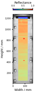
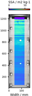
Specific surface area is derived by applying an exponential calibration function to the near-infrared reflectance image captured at 940 nm. The result is a two-dimensional SSA map that allows spatial structures within the snowpack to be visualised at millimetre resolution. The figures below illustrate the workflow from a reflectance image to a calibrated SSA map and a vertically averaged SSA profile. The rightmost figure shows a comparison between SnowImager-derived SSA values and measurements obtained with the IceCube instrument. The black line represents the full spatial resolution of the SnowImager, while the red line shows the profile resampled to match the IceCube resolution.
Near-infrared (NIR) reflectance profile of snow stratigraphy measured with the SnowImager
SSA calibrated SnowImager profile
Horizontally averaged SSA values of SnowImager compared to the SSA values determined with the IceCube instrument
Density
For density retrieval, a mountable grid plate is attached to the SnowImager to create vertical slits with defined widths between 10 and 30 mm. Snow density is derived from the reflectance behaviour within these slits. The reflectance signal decreases toward the slit edges depending on the density of the snow. This patented measurement principle was developed specifically for the SnowImager system.
Liquid Water Content (LWC)
The potential to derive liquid water content is currently explored.